
| Dear Livingmaps subscribers, We are looking forward to beginning a new seminar series, Mapping Fluid Worlds. Please join us for the first in the series: Anne-Laure Fréant 29th October, 6pm UK online The Flood Necklace: an exploration of how data-sculpture can carry a river’s history Tickets here: https://www.eventbrite.co.uk/e/the-flood-necklace-anne-laure-freant-tickets-1780458071019 |
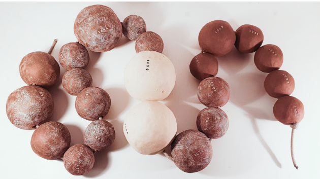
| The Flood Necklace is a data object (or data sculpture) that embeds water-level data from all recorded flood events of the Loire River in the city of Orléans, spanning 1800 to 2003. This object questions the conventional ways we represent and record flooding (typically through 2D maps) and explores alternative forms for representing, storing, sharing, and remembering environmental histories. It also raises the issue of the “vertical axis,” a dimension critical in river stratigraphy but difficult to visualize without 3D modeling—and even harder to sculpt into physical objects, making our conception of river’s shapes often “present-based.” We also present other data objects that attempted to record and display historical environmental data as part of an ongoing reflection on river histories’ representation. Anne-Laure Fréant is a geographer by training, having studied natural risks and cultural geography in France and Canada for seven years. After her studies, she began a career in IT but maintained a strong interest in colonial and environmental history, especially in Canada. She discovered the field of data physicalization while working for the French open data administration and is now exploring how the creation of data objects can enrich the ways we record, understand, and remember environmental history. |
| We hope you can join us! Best wishes, Heather and the Livingmaps team The Flood Necklace is a data object (or data sculpture) that embeds water-level data from all recorded flood events of the Loire River in the city of Orléans, spanning 1800 to 2003. This object questions the conventional ways we represent and record flooding (typically through 2D maps) and explores alternative forms for representing, storing, sharing, and remembering environmental histories. It also raises the issue of the “vertical axis,” a dimension critical in river stratigraphy but difficult to visualize without 3D modeling—and even harder to sculpt into physical objects, making our conception of river’s shapes often “present-based.” We also present other data objects that attempted to record and display historical environmental data as part of an ongoing reflection on river histories’ representation. Anne-Laure Fréant is a geographer by training, having studied natural risks and cultural geography in France and Canada for seven years. After her studies, she began a career in IT but maintained a strong interest in colonial and environmental history, especially in Canada. She discovered the field of data physicalization while working for the French open data administration and is now exploring how the creation of data objects can enrich the ways we record, understand, and remember environmental history. We hope you can join us! Best wishes, Heather and the Livingmaps team |